Tuesday 14 September 2010

Tectonics: human imapct and management

Earthquakes impact humans in many different ways and it is probably fair to say that people in LEDC suffer more than MEDC's. Potential impacts include:
1. short-term (immediate) impacts
2. long-term impacts
3. social impacts (the impact on people)
4. economic impacts (the impact on the wealth of an area)
5. environmental impacts (the impact on the landscape)

A way in which the impacts could be studied would be to try to think of the impacts and then consider actual case studies. Students can look at the severity of the impacts comparing LEDC and MEDC's.

The following information is taken from the BBC web site and is a concise summary of the general effects.

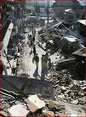
Short-term (immediate) impacts People may be killed or injured. Homes may be destroyed. Transport and communication links may be disrupted. Water pipes may burst and water supplies may be contaminated.

Economic impacts:Shops and business may be destroyed. Looting may take place. The damage to transport and communication links can make trade difficult.

Environmental impacts: The built landscape may be destroyed. Fires can spread due to gas pipe explosions. Fires can damage areas of woodland. Landslides may occur. Tsunamis may cause flooding in coastal areas.


Long-term impacts Social impacts:Disease may spread. People may have to be re-housed, sometimes in refugee camps.

Economic impacts:The cost of rebuilding a settlement is high. Investment in the area may be focused only on repairing the damage caused by the earthquake. Income could be lost.

Environmental impacts:Important natural and human landmarks may be lost.


Generally the effects of an earthquake are more keenly felt by a LEDC's than a MEDC's for numerous reasons and the student can try and think about the differences in the 2 that might contribute to the differential. These will include;
1. Communication systems may be underdeveloped, so the population may not be well educated about what to do in the event of a volcanic eruption or an earthquake.
2. Construction standards tend to be poor in LEDCs so building suffer more damage.
3. Buildings collapsing can cause high death tolls.
4. Evacuation and other emergency plans can be difficult to put into action due to limited funds and resources.
5. Clearing up can be difficult. There may not be enough money to rebuild homes quickly and safely. Many people could be forced to live in emergency housing or refugee camps.

Students can apply difficulties to case studies such as the quake in Japan 1995 (MEDC) and the recent quake in the South Pacific (LEDC). Comparisons can be made as to death tolls, building destroyed, those left homeless, the re structuring costs, spread of disease and aid provided to name but a few.

Tectonics: Earthquakes


Earthquakes are one of the most frightening and power natural disasters.
They occur along tectonic plate boundaries in the same way of volcano's. As the plates move pressure in the earth builds and the tension is released via earthquakes. This map shows the global position of the plates.


The area in the earth where the earthquake starts is called the focus or the hypocentre. The centre of the quake on the surface is called the epicentre. I have previously considered the merging of coming together of plates in the blog entitled 'plate tectonics' (not unsurprisingly!) so i am just going to look at the measuring of quakes, the types and then the effects in the next blog.

The machine used to record the power of an earthquake is a seismometer and the value that is placed is assigned under the Reciter scale, the higher the score on the scale the more serious the earthquake. Low score quakes can occur frequently on certain boundaries, with limited damage.

There are 2 types of earthquake with different types of waves of energy. The first is when the waves create a rolling up and down motion called Rayleigh waves and Love waves that cause the ground to twist from side to side. There are earthquakes that occur on land and out at sea and it is the latter that then lead to a tidal wave AKA a tsunami. As well as the initial quake there are also aftershocks that may not be as powerful but can be devastating.

When looking to teach this subject there are many recent examples of severe earthquakes e.g.China's south-western Sichuan province in May 2008 measured 7.8)and tsunamis e.g. Thailand on December 26, 2004. Consideration of the cause/origins and human consequences should bring the subject to life and make it very memorable.

Thursday 9 September 2010

Volcanic processes and Landscapes

We need to look how and where a volcano is formed. They occur on land and under the sea on constructive and destructive plate boundaries. They emit magma that as it hits the surface becomes lava. At the plate the pressure under the crust builds and finally breaks through the surface in the form of a volcano.

Volcano's are frankly awesome given their power of construction and destruction. There are features of a volcano that can be taught by diagram form and annotating. Enchanted learning has a great example. Students need to know the components that are listed below.

ash cloud - an ash cloud is the cloud of ash that forms in the air after some volcanic eruptions.
conduit - a conduit is a passage through which magma (molten rock) flows in a volcano.
crust - the crust is Earth's outermost, rocky layer.
lava - lava is molten rock; it usually comes out of erupting volcanoes.
magma chamber - a magma chamber contains magma (molten rock) deep within the Earth's crust.
side vent - a side vent is a vent in the side of a volcano.
vent - a vent is an opening in the Earth's surface through which volcanic materials erupt.

These can then be inserted onto the diagram below


There are 2 types of volcanoes: Shield (constructive) and Composite (destructive). They look difference and have different effects.

Shield volcano Shield volcanoes are usually found at constructive or tensional boundaries.They are low, with gently sloping sides and formed by eruptions of thin, runny lava. Eruptions tend to be frequent but relatively gentle.

Composite volcano Composite volcanoes are made up of alternating layers of lava and ash (other volcanoes just consist of lava). They are usually found at destructive or compressional boundaries. The eruptions from these volcanoes may be a pyroclastic flow rather than a lava flow. A pyroclastic flow is a mixture of hot steam, ash, rock and dust. A pyroclastic flow can roll down the sides of a volcano at very high speeds and with temperatures of over 400° C.

Many of the syllabuses in schools suggest a case study, I have seen the Mount St. Helens in a MEDC via video, Google Earth and annotation, each method brought the example to life. There are others such as Chances Peak, Montserrat, 1995-97 – an LEDC.

Tectonics: Plate tectonics

Before looking at plate tectonics we should first consider the structure of the earth. In the centre is a solid core. Surrounding the core is the inner core, then the mantle, which is covered in the earths 'skin' or crust.

The temperature of the earth reduces from the core (hottest) to the mantle and then the crust that is either continental crust (carrying earth) or oceanic (carrying water). The crust is made up from plates. the plates move with via the convection currents cause by the radioactive break down of the earths core. This movement is called Plate tectonics . It is plate tectonics that cause the creation of volcano's and earthquakes at a point where the plates meet. the diagram below shows the earth plates.


The plates have moved over many millions of years to form the continents as they currently exist.
The Earth's plates move in different directions

Plates behave differently at different plate boundaries:
1. At a tensional, constructive or divergent boundary the plates move apart.
2. At a compressional, destructive or convergent boundary the plates move towards each other.
3. At a conservative or transform boundary the plates slide past each other.

Tensional/Constructive Margins plate boundaries occur when two plates move away from each other. This allows magma to come to the surface, which hardens into ingenious rock. This can occur over a long period of time but eventually a volcano can develop.

At a compressional or destructive boundary the plates are moving towards each other. This usually involves a continental plate and an oceanic plate. t occurs when a occur when an oceanic plate is forced under (or subducts) a continental plate. as the plates are pushed together they are force upwards causing fold mountains, such as the Alps in Europe.


Conservative (transform faults) plate boundaries occur when two plates slide past each other.


Collision plate boundaries Collision plate boundaries occur when two continental plates move towards each other.


The movement of tectonic plates creates dramatic volcanic eruptions and earthquakes over which the human world has no control, although attempts have been made to manage the effects obviously not the causes.

Wednesday 8 September 2010

Extreme lanscapes: Periglacial landforms

Many periglacial landforms are at ground level and can be symmetrical with geometric shapes. The causes of the landforms are often not clear apart from the obvious that they have been generated by one of the processes discussed in the previous blog.

One of the landforms with what i think is a great name is a Pingo. It is an ice core hill.
The Pingo in this picture is in Canada. They generally have a curved top with ice in it, that can melt. Pingos can continue to grow due to the freeze thaw bringing sentiment to the surface.


Ice-wedge polygons are fantastic natural phenomenon and an example of patterned ground. The ones in this picture are found in Hudson Bay Lowlands, Manitoba Canada. The Brown polygons mark the location of massive ice wedges that extend from the surface down to 2 or 3 m.


Plasas are smaller hills of segregated ice and peat. It develops as the vegetation growing in the peat is forced up by the segregated ice underneath so that they die just leaving the pert mound.


The true understanding of the development of some landforms is still debated but they are an interesting contrast to those formed by glacier and rivers. Students could be asked ion a test to distinguish landforms of all 3 landscapes. Contrasting allows them and the teacher to reflect on the learning that has taken place and if certain subjects needed to be revisited.

Extreme landscapes: Periglacial processes

There are 4 main processes that I am going to look at, with the help of the fantastic PhysicalGeography.net web site.

Weathering
This is essentially the freeze and thaw that causes large fragments of rock to be fractured from the main body of rock as the water crystallises, expanding its volume and pressure in gaps and seems in the rock.

Ground Ice
The most common form of ground ice is pore ice. Pore ice develops in the pore spaces between soil and sediment particles where liquid water can accumulate and freeze.

Ice wedges are downward narrowing masses of ice that are between 2 to 3 meters wide at the base and extend below the ground surface up to 10 meters. It is believed that they form when a seasonal crack in the ground forms in the winter. The diagram below shows the process:


Mass movement
The are different types of mass movement including Solifluction which is the downward movement of soil particles that are saturated. the slope does not have to be steep for this to happen. Also Frost creep which is the movement of similar soil and sediment but this is caused by frost freezing and melting. Particles move slowing through this process and gravity. Another type is rock falls as periglacial environments are harsh soil does not deposit easily and there is a lot of bare rock that is exposed the the harshness of the weather causing cracking etc causing the rocks to become unstable.

Erosion
Processes of erosion and deposition in periglacial parts of the world tend to have their own unique character. These characteristics are related to the importance of freeze-thaw action, the presence of strong winds, and the fact that the warm season is very short.

The landforms that have developed due to these processes are remarkable in character and will be discussed in the next blog. Understanding these processes could be contrasted with the processes of the riparian environment.

Extreme landscapes: Periglacial, general

A periglacial environment is one that can be located next to a glacier and therefore influenced by permafrost, freeze/thaw. But permafrost also exists in areas that are not associated with glaciers and so the definition can be extended.

Permafrost is a condition where a layer of soil, sediment, or rock below the ground surface remains frozen for a period greater than a year. Permafrost is not a necessary condition for creating periglacial landforms. However, many periglacial regions are underlain by permafrost and it influences geomorphic processes acting in this region of the world (PhysicalGeography.net). Permafrost land covers 25% of the non glacial land surface.

Permafrost can be very thick but generally it is the first 1 to 3 meters of it that can be subject to a thaw in the summer months. Almost 50% of Canada is covered in permafrost as can be seen from the diagram below:

In the next couple of blogs I will look at the periglacial processes and landforms.

Extreme landscapes: Glacial landforms 2

Carrying on from the last blog (Glacial landforms 1) I am going to have a look at the deposition landforms.

Moraines

A moraine is rock deposit that has been laid down by the glacier. There are 4 different types:


  • Terminal/end moraines are found at the terminus or the furthest (end) point reached by a glacier
  • Lateral moraines that are found along the sides of the glacier
  • Medial moraines are found where 2 glaciers meet
  • Ground moraines that are basically disorganised groups of different types of rocks


Other formations include Drumlins that are streamlined, elongate hills composed of glacial drift. Drumlins are often found in swarms; their tapered end pointing in the direction of glacier advance.


Erratics are rocks of different shapes and sizes that are simply dumped by the glacier.


The landforms of glaciers can in my view be inspiring and outstanding, giving us a real insight in to the power of the earth. Some are deemed the most remarkable forms on earth creating amazing physical geography. There can be nothing better than getting on those walking boots and striding out over the glacial landscape of the Lake district. We can only be in awe of the power of the glacier.

Extreme landscapes: Glacial landforms 1

There are many different landforms created by glaciers, which is not surprising even their prevalence, size and power. I am going to split them into 2 types erosion and deposition, it could as easily be divided into upland and lowland formations. I am going to have a look at erosional landforms in this blog and depositional landforms in the next. This should allow me to use a few pictures of the magnificent landforms features.

Erosion formations This is a Cirque. generally found at the start of a glacier. It is a bowl-shaped depression eroded into the side of a mountain by an alpine glacier.


Pictures say a thousand words and this diagram shows how the cirque is formed.


This is a U shaped valley that typically have steep sides and flat floors. The glacier widens, steepens, deepens and smooths pre-existing V-shaped river valley.


A hanging valley occurs when a tributary rivers joins the U shaped valley that is lower. It often leads to spectacular waterfall.


When a river erodes the landscape, ridges of land form in its upper course which jut into the river. These are called interlocking spurs. A glacier cuts through these ridges leaving behind truncated spurs


An arête is a knife-edge ridge. It is formed when two neighbouring corries run back to back. As each glacier erodes either side of the ridge, the edge becomes steeper and the ridge becomes narrower, eg Striding Edge found on Helvellyn in the Lake District. (BBC bitesize)


A pyramidal peak is formed where three or more corries and arêtes meet. The glaciers have carved away at the top of a mountain, creating a sharply pointed summit, eg Mont Blanc, The Matterhorn and Mount Everest. (BBC bitesize)


Other formations develop such as ribbon lakes that occur after the glacial has melted, they are often deep and flat bottomed. Roches moutonnée and Crag and tail are formations that develop when there is a change in the type of rock that the glacier passes over.

The erosional formations can create dramatic scenery and exciting places to visit often in National Parks.

Extreme landscapes: Glacial Processes

So from the previous blog we know that glaciers move, they ate massively heavy and as they move they change the land that they travel over.

The main erosional processes are Freeze/thaw, plucking and abrasion.


Freeze-thaw is when melt water or rain gets into cracks in the bed rock, usually the back wall. At night the water freezes, expands and causes the crack to get larger. Eventually the rock will break away.

Plucking is when melt water from a glacier freezes around lumps of cracked and broken rock. When the ice moves downhill, rock is plucked from the back wall. It leaves behind a jagged landscape.

Abrasion is when rock frozen to the base and the back of the glacier scrapes the bed rock. This causes the wearing away of the landscape as the glacier behaves like sandpaper. It leaves behind smooth polished surfaces which may have scratches in them called striations. Striations are carved out by angular debris embedded in the base of the glacier.

In terms of teaching glacial processes my view is that it should be linked to the landforms created so that they is something tangible to examine. The next blog will show the formations giving pictorial examples. I have found some great video's online but I am yet to work out how to upload them to the blog. These would be very helpful in providing a visual explanation. Also, if it were possible a field trip to the lakes would be great to show the students the processes and the results....money permitting of course!

Tuesday 7 September 2010

Extreme landscapes: Glacial, general


Glaciers are huge masses if snow and ice that have been compacted over many thousands of years. Their weight is such that when they move they do so very slowly the bottom slowed by the ground. They originate from the 'ice age' (18,000 years ago, covering 1/3 of the earths surface) and as the earth has warmed they have melted and reduced in size. Having said that they still cover 10% of the earth. When the majority of the glaciers melted (after the ice age) they left behind changed landscapes that will be discussed in the next blog. A local example of a glacial landscape is the lake district.

In the high mountains of Britain we can see the effects of glaciers. This is the Buttermere valley in the Lake District. This valley would have been filled by ice. The valley has been straightened and deepened by the erosion. This type of valley is called a U-shaped valley.

Extreme Landscapes: Desertification/human processes

This is a subject that interests me as you can look at the interaction/juxtaposition of physical and human geography. It is a great example of how geography is a current and dynamic subject, by looking at the cause and effect of 'natural' (if there is such a thing) and anthropological impacts.

What is desertification?

The transformation of arable or habitable land to desert, as by a change in climate or destructive land use. This picture shows how with over farming a poor farming methods the soil has become infertile, allowing the desert to move in.


Human processes

The following is a quote from Kofi Annan (UN General Secretary) 2003, altering the world to the dramatic and devestaing effect of desertifcation on human populations. the quote is from mindfully.org. 'Desertification and drought pose an ever-increasing global threat. Human activities such as overcultivation, overgrazing, deforestation and poor irrigation practices, along with climate change, are turning once fertile soils into unproductive and barren patches of land. Arable land per person is shrinking throughout the world, threatening food security, particularly in poor rural areas, and triggering humanitarian and economic crises.'


The graph shows the type of land use in each world area that is causing desertification. The map below shows how vulnerable Africa is to this process especially when you bare in mind that level of poverty on this continent, which will affect their attempts to combat the problem.


The economic problems that will develop as a consequence of desertification are significant, including reduced food production leading to rural communities breaking down, internal migration, external migration and possible conflict. The situation is urgent and needs a global response, but whether this will happen given that those most affected have little 'global power' remains to be seen. it is this type of issue that students can reflect upon and consider possible solutions and developing their own ideas on global issues.

Extreme Landscapes: Desert Landforms

Deserts have a variety of landscape features. Teaching this subject could be tricky but there are some fab web sites on teaching methods and resources, including howstuffworks.com, enchantedlearning.com. This is one of the alien environments that we will learn about and it is important to reflect of the method of teaching to try and bring the subject to life.

Sand dunes: the landforms commonly thought of as typical of deserts, occupy only a relatively small part of the world's deserts. Some deserts, however, have great expanses of dunes, known as sand seas, or ergs.


Yardangs: Bare rock surfaces they occur where wind and water have removed the surface particles and left the hard bedrock exposed. Commonly, flat areas are covered by what is known as a desert pavement, a closely compacted layer of rock and gravel. In some places, especially at the foot of a mountain, there are large deposits of gravel and other coarse debris, which are sometimes quite deep.


>

Arroyos: Floods occur and form temporary rivers that carve steep-sided valleys called dry washes or wadis.


Playas: occur when water is carried by floods sometimes accumulates in shallow depressions in the desert floor. Playa lakes usually disappear quickly and leave behind sand, silt, and dissolved minerals, which may form salt flats. There can be permanent water features—such as the Great Salt Lake, in Utah, USA.


Ventifacts: Rocks that are shaped by the wind and occur in deserts due to the Strong winds that carry sand particles. They are shaped by this process of saltating.


There are many more examples of the desert feature but the ones i have shown here are the basics!

Monday 6 September 2010

Extreme Landscapes: desert processes


What is a desert?

It is a region with so little vegetation that no significant population can be supported on that land. This implies that it is dry, but not necessarily hot. However, for the purposes of this blog I will consider mid latitude deserts in the interior of continents characterized by low rainfall and high summer temperatures, e.g., Gobi Desert of Mongolia.

The dominant force in a desert is wind. Wind can also cause erosion and deposition in environments where sediments have been recently deposited or disturbed. Erosion by wind is slower than water or ice, but it can move material up and down a slope unlike water. But as the wind velocity increases as does the winds erosive power.

Wind erosion

Removal of loose sediment by the wind. Sediment must be dry. Sand and silt sized material will be moved. Larger material is generally left behind
Abrasion is a physical weathering process. AKA Sand blasting. Impact of windblown particles on exposed surfaces will remove material from that surface
Abrasion will also reduce the size of the particles that are being moved
Generally limited to heights of 1 meter (2 meters max.)

Deposition

In a desert, material moves primarily by the wind through a process called saltation. Deposition occurs in areas where a pocket of slower moving air forms next to much faster moving air. Such pockets typically form behind obstacles like the leeward sides of slopes. As the fast air slides over the calm zone, saltating grains fall out of the air stream and accumulate on the ground surface. (PhysicalGeography.net).

There are different types of sand dunes and desert landforms that i will look at in the next blog. Perhaps to help the students understand the movement of sand we cold look at sand closer to home that is the beach where dunes occur.

Riparian Environments: Landforms

Landforms: A way of teaching this element could be by way of a quiz, differentiating on learning abilities, using graphics and basic pictures to learn where certain landforms are located on the length of a river (that is upper middle or lower course of the river). I love the formations that rivers create, the diversity of physical shapes formed by the shear power of water. Amazing!

Upper Course

The steep gradient and narrow flow of the river helps to form features such as V-shaped valleys, waterfalls, gorges and interlocking spurs. These formations can be spectacular:

Interlocking spurs


Waterfall: formed as water passes over a variation hard rock and softer rock causing erosion of the soft rock.


Middle Course
the gradient is more gentle but the river has high volumes of water and energy. It travels along through flatter areas allowing it to create different types of land forms, including large meanders (bends in the river). As the river meanders the speed of the the water on the inside of the curve is slower so that it deposits material, whereas on the outside of the curve it travels more quickly and therefore erodes the bank. This makes the bends even more extreme


Over time the horseshoe become tighter, until the ends become very close together. As the river breaks through, eg during a flood when the river has a higher discharge and more energy, and the ends join, the loop is cut-off from the main channel. The cut-off loop is called an oxbow lake.


Lower Course

This element has high volume and large deposits. the river is moving slowly often towards its mouth. It can have a large flood plain which over time has deposited very fertile alluvium (sediment) that is great for farming. On reaching the mouth a delta is formed. See my previous blog on river processes and the picture of the Okavango Delta.

Riparian Environments:River processes

There are 3 main types of river process:

Erosion
Transportation
Depositing

Erosion
The wearing away of rock on the river bed and banks. There are 4 main types: (see BBC bite size

Hydraulic action – the force of the river against the banks can cause air to be trapped in cracks and crevices. The pressure weakens the banks and gradually wears it away.
Abrasion - rocks carried along by the river wear down the river bed and banks.
Attrition - rocks being carried by the river smash together and break into smaller, smoother and rounder particles.
Solution - soluble particles are dissolved into the river.

Transportation
This is the movement of elements by a river. The diagram shows the different methods. the amount of material being carried is really dependent on the energy of the river. The slower it runs the less it transports, such as on plains or near its mouth.


Deposition

As the word suggests as the river slows it deposits material generally as the volume of water reduces say in times of drought or when it slows at the mouth or in a delta. one of the most amazing deltas is the Okavango Delta in Botswana. It is produced by a seasonal flood and as the water meets the plain that only has a height 2 meter height variation it slows and deposits material.


I have obtained much of this information from the BBC Bite size web site. it is a good revision tool available to all.

Riparain Environments: Drainage basins


The functioning of a drainage basin as an open system with inputs, outputs, transfers, stores and feedback loops.
A good definition of a a drainage basin is 'The entire geographical area drained by a river and its tributaries; an area characterized by all runoff being conveyed to the same outlet.'

Referring to the previous blog (Riparian environments:general) the Amazon has the largest drainage basin the the world.

How does water enter the drainage basin and can this be measured?
Most of the water in a basin emanates from precipitation but some comes from ground water. the diagram above shows the way in which the water enters the drainage basin. (Of course this is all part of the wider hydrological cycle).

Studying the history of the amount of water allows people to consider such things as water usage for rural and urban environments,the possibility of drought or flooding. The data often collected by a stream gauge is presented in the form of a hydrograph.

A hydrograph shows changes in water levels over a specific period of time.


There are spatial and temporal (short-term and long-term) variations in hydrographs. So for example you would expect a river passing through the Alps of Europe during spring to have a large volume of water due to snow melt. The graph would then peak when the flow of water is at its greatest.

An examination of hydrographs in forecasting allows people to attempt to predict the magnitude, spatial extent and timing of floods and of course droughts.

In terms of teaching, a stream study could be undertaken over a period of a few months via a stream gauge and the results plotted on a hydrograph. The web (teaching sites and GA site) and various OU books have been used to prepare this blog. There is a wealth of information on how to carry out a study.

Riparian Environments: general


Riparian is the correct name for one of the 15 bimoes on earth. A biome is a large community of plants and animals that occupies a distinct region in the case rivers. The area where the river meets the land is called the riparian zone. Of course rivers/steams exist all over the earth passing through massivily different environments, take the huge Amazon river in South America and a small stream: diverse to say the least!