One of the landforms with what i think is a great name is a Pingo. It is an ice core hill.
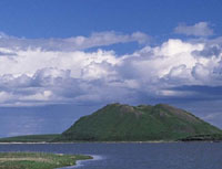 The Pingo in this picture is in Canada. They generally have a curved top with ice in it, that can melt. Pingos can continue to grow due to the freeze thaw bringing sentiment to the surface.
Ice-wedge polygons are fantastic natural phenomenon and an example of patterned ground. The ones in this picture are found in Hudson Bay Lowlands, Manitoba Canada. The Brown polygons mark the location of massive ice wedges that extend from the surface down to 2 or 3 m.

 Plasas are smaller hills of segregated ice and peat. It develops as the vegetation growing in the peat is forced up by the segregated ice underneath so that they die just leaving the pert mound.
The true understanding of the development of some landforms is still debated but they are an interesting contrast to those formed by glacier and rivers. Students could be asked ion a test to distinguish landforms of all 3 landscapes. Contrasting allows them and the teacher to reflect on the learning that has taken place and if certain subjects needed to be revisited.
No comments:
Post a Comment