
The functioning of a drainage basin as an open system with inputs, outputs, transfers, stores and feedback loops.
A good definition of a a drainage basin is 'The entire geographical area drained by a river and its tributaries; an area characterized by all runoff being conveyed to the same outlet.'
Referring to the previous blog (Riparian environments:general) the Amazon has the largest drainage basin the the world.
How does water enter the drainage basin and can this be measured?
Most of the water in a basin emanates from precipitation but some comes from ground water. the diagram above shows the way in which the water enters the drainage basin. (Of course this is all part of the wider hydrological cycle).
Studying the history of the amount of water allows people to consider such things as water usage for rural and urban environments,the possibility of drought or flooding. The data often collected by a stream gauge is presented in the form of a hydrograph.
A hydrograph shows changes in water levels over a specific period of time.
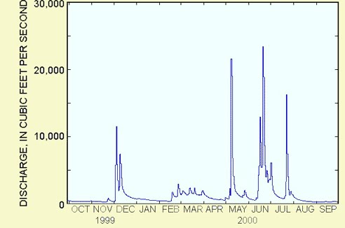
There are spatial and temporal (short-term and long-term) variations in hydrographs. So for example you would expect a river passing through the Alps of Europe during spring to have a large volume of water due to snow melt. The graph would then peak when the flow of water is at its greatest.
An examination of hydrographs in forecasting allows people to attempt to predict the magnitude, spatial extent and timing of floods and of course droughts.
In terms of teaching, a stream study could be undertaken over a period of a few months via a stream gauge and the results plotted on a hydrograph. The web (teaching sites and GA site) and various OU books have been used to prepare this blog. There is a wealth of information on how to carry out a study.
No comments:
Post a Comment